Thursday, March 30, 2006

Tora, Tora, Tora


Back in the Tiger! The log book says that last flight in a Tiger was back in June 2005.

Objective of this flight: get checked out in the American General AA5B.

I reviewed the POH to get familiar with the speeds and systems. (No prolonged descents at 1850 to 2250 RPM. Start the engine on the left mag, etc.). I got to the airport a little early so that I could take my time getting reacquainted. I bought a brand new laminated checklist and walked out the airplane. She is not a showgirl, looks like some hail damage, numbers are faded and walk areas on the wings need work, but she still looks good to me. The engine compartment is the cleanest I've ever seen, and the interior is nice new leather. A new stack (including a Garmin 430) is expected to be installed this week.

I'm excited to be back in the Grumman again, and nervous (although I shouldn't be) to have an instructor looking over my shoulder for the check out ride. I don't want to disappoint him. The plan is to stay in the pattern, do some T&Gs, and if we still have some daylight, go north and do some high work.

Startup, taxi and runup are all normal. (WOW, as I'm taxiing out a Piaggio Avante lands. Just Gorgeous! OK, when I win the lottery...) RYY is busy. There must be 3 or 4 planes doing the ILS, as well as traffic in the pattern. While I still enjoy just sitting in an airplane, the CFI is ready to go. Change in plans, lets depart here and go over to Cartersville.

Take off is normal, however the nose attitude is much lower then the C172. I can actually see where I'm going. Airspeed is in MPH with the inner ring in Knots. Climb at about 105 mph. Its a beautiful spring evening out there, and the visibility from this airplane is spectacular.

Two other airplanes in the pattern, with another entering on the 45 about 5 miles out. I make the calls and take interval, ask the CFI to show me one so I can get the picture again. Round out is a little lower as is the nose attitude on the flare. My turn.

I call crosswind and hear chatter about the pattern being so busy. It makes me laugh (4 airplanes is NOT busy.) First landing goes well (I'm in love again.) The next has to be extended very deep due to traffic, but also goes well. Downwind on the next he pulls the engine. Best glide is 83 mph, I look over my shoulder and extend the pattern a bit. This airplane likes to fly. Base is still high, full flaps before turning final and a full slip brings her down nicely. Straighten out and he tells me to execute a go around. No problem. Let's go home.

Normal entry back home (well, actually by this time I'm more familiar with the ILS) and no traffic. Cleared to land. Here I break one of my rules, no chatter once on base leg. I guess the relief and excitement got to me. I missed a tower call, and he caught it. Lesson relearned. Landing was not great, but acceptable.

Overall a very good flight. I'm going to love flying this airplane.

AA5B
Time = 1.6

Monday, March 27, 2006

Rome, Georgia


Nate had come home from Spring Break with a brand new Student Pilot's certificate for a Sailplane. Now he wanted to compare what he had learned with powered flight. Well, any excuse to fly sounds good to me.

Objectives of this flight: VFR flight rules, touch and goes, and radio communications.

Cold fronts have still been passing through Georgia stirring up the air. Ceiling and visibility was great, but preflight planning showed winds were gusting up to 20 kts with nearly 90 degree (variable) crosswinds. Forecast was for the winds to subside later in the day.

We arrived at the airport about 6:00pm local. The plane was already back from a previous flight so we were able to get the dispatch kit and start the preflight almost immediately. I took some time to brief him on the plan. He would handle the radio with ground/tower, and after takeoff fly to the Rome VOR. Enter the pattern trough the ILS approach, do some bounces, depart and get vectors to the ILS back home with a night landing.

Taxi and runup all normal. His communications work was good. (Listening on his transceiver over the past few months definitely helped.) The pattern was busy for a Sunday afternoon and Tower was able to squeeze us in for takeoff just in front traffic on base. He made a nice takeoff with a gusting right crosswind and climbed to 4500 on course to the VOR. The expected turbulence was nil. Since this was a VFR flight, I had him get outside reference and told him to fly just left (south) of the cooling towers at Cartersville. (I never realized that this is a coal powered generating plant.)

I explained 'AMICEATM' and set him up for the ILS 01 at KRMG. He had flown this on MS Flight Simulator, so thought this would enable him to make a nice comparison. I walked him though the parallel entry, timing and intercept for the final approach course. The whole time I was talking to traffic. Two other planes were using Rome, one in the pattern and one on a VOR approach behind us. No factor, but I relaxed once we all saw each other. Having a landing light on at dusk really helps. He did a nice job all the way down.

I knew it was a left hand pattern, but what was the pattern altitude? (Note to self; check this in the Airport Directory BEFORE getting into the pattern.) I guessed at about 1100 ft (missed approach height), it turned out to be 1440 ft, so obviously the first approach was low. Corrected to 1500 ft for the next orbit which worked well. Finally, he had learned to do slips in the sailplane, so I flew a high (+300 ft) approach and slipped it in for him. Not as dramatic as a sailplane, but effective. Departed the pattern and headed for home.

It was full night time now and as always, beautiful. Cartersville passed under our right wing and the air was smooth as glass. Nate did a good job of maintaining 3500 ft as I dialed up Atlanta Approach to see if we could get vectors. Ran into a minor problem here, as the GPS display was dimming too far. When I pointed my flashlight on the sensor I could get it bright enough, but then in would automatically dim back to a low level. While this works, it was distracting so I asked the chief pilot about when we got back to the school. One fix it to go to the last AUX page, select Display, and go from AUTO to MANUAL with the small knob.

"Squawk 0123 (did I hear that right?) maintain 3500 and fly heading 110." Nate flew and I did the readbacks. Nice smooth turns and good airwork on the ILS. Cleared to land #2 behind a Caravan. No problems. A great evening flight. We went 149 miles, got up to 4747 feet and a max ground speed of 147 mph, and we had fun.

C172p
Time = 1.6

Friday, March 17, 2006

Just Practice Approaches


My flying partner put together a list of objectives to consider when planning our flights. He summed it up this way:
So we have three categories of flying:
I. Fun Cross Country
II. Instrument Approach Hopping
III.Busy Cross Country with Instrument Approaches.
After the serpentine approach I flew last week into KPLR, I decided I really need to work on II. The objectives of this flight were 1) basic airwork and 2) simulated instrument approaches.

We both arrived at the airport at 4:00pm local, after a rather stressful day at work. Conference calls, email, phonemail and powerpoint presentations were still unanswered and incomplete, and I was weary from the confrontations and compromises made throughout the week. I sensed he felt about the same. However, there is just something refreshing about preflighting an airplane on a beautiful Springtime afternoon that helps to melt the real world away.

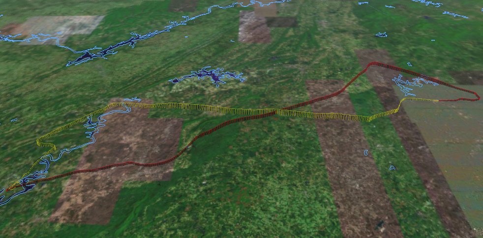
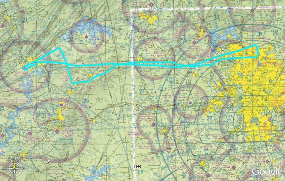
The plan was for him to take the first leg, do the ILS at KRMG to a low approach, then the ARC/GPS at C22 to a full stop. There we could switch seats and I would take us east to 47A for a GPS low approach, and finally vectors for the ILS back home to KRYY. Nothing new here, we had both flown these approaches before. Weather was not predicted to be a factor.

Preflight was normal except for one point. The plane had just come back from a previous flight, and when I checked the oil it was down around 4. I had another quart put in. I was told that I should have considered that there was still oil in the engine and that this was probably an overfill. Well, maybe. It may have put me over 6, but definitely under 7.

Taxi, runup and takeoff were all normal. He had his foggles on before passing 2000 and climbed on course to 4500. There was a broken level above us at about 8000, little bumps in the air and smog/smoke drifting in from the west. We also had an annoying 'tornado' in the airplane due to fact that we couldn't close an air vent.

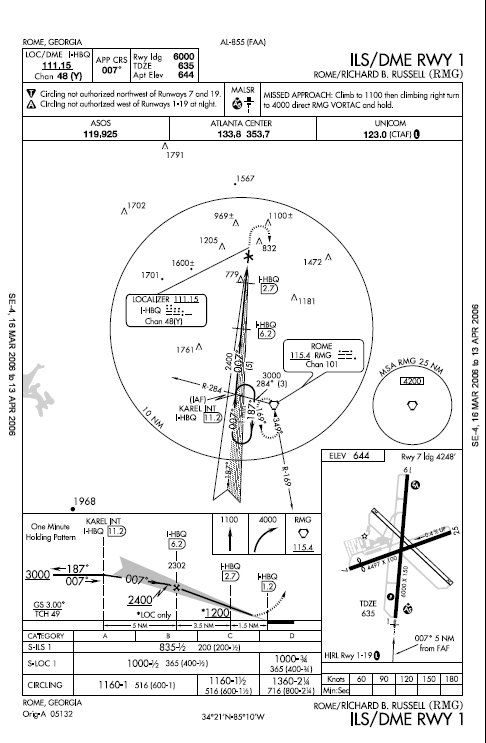
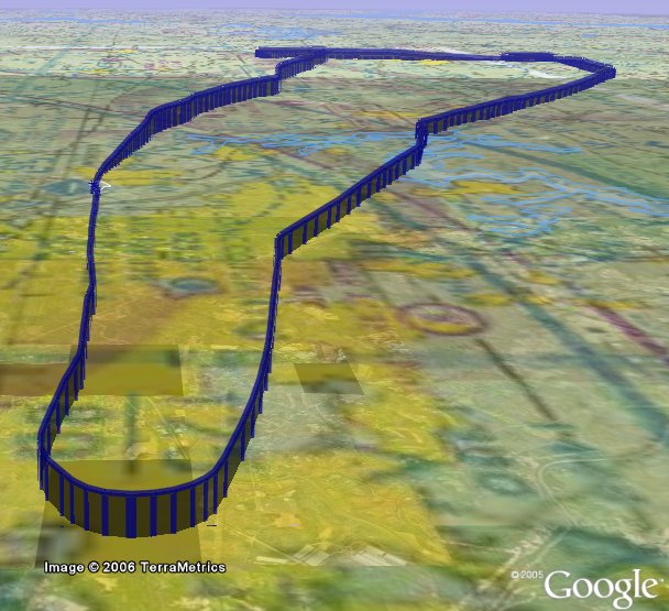
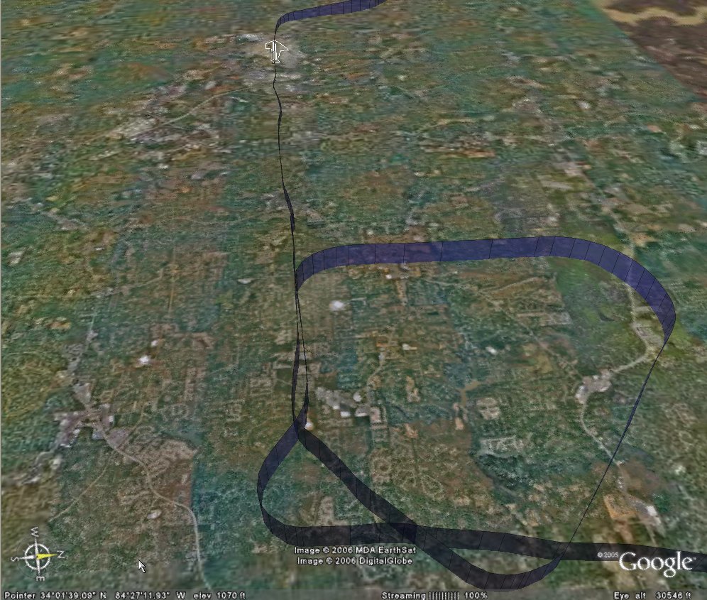
His first chore was to track inbound to the VOR, then enter holding for the procedural turn. Rome isn't that far away from Cobb County, so he was kept busy with checklists and instrument procedures while I looked for traffic and checked in with the other folks using the VOR and landing pattern. He got a little behind the airplane trying to do his 'Ts' and 'AMICEATM' but overall flew a pretty good approach down to mins. We could have made the landing.

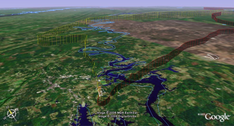
Missed there (carefully watching for cross traffic) and climbed back to the VOR. Opposing traffic was inbound to the field and the smoky haze made seeing him difficult. We passed well clear, no factor. Next setup was for the GPS into Centre Municipal in Alabama. The IAF happens to be about a mile Southeast of Cedartown, so I was glad for the silence on CTAF. I didn't want to be in the middle of a shower of Skydivers.

He used the GPS as primary and backed it up with the VOR. The arc went very well and he rolled out nicely on course. As we traveled the 15 miles to the airport, we both noticed a discrepancy in the needles. The VOR had us right of course, while the GPS had us dead on. I advised him to stay with his primary. Haze obscured the field until about 5 miles and at that point I knew that the VOR was giving a better indication. (I would have expected the GPS to be more accurate.) When he took the foggles off at mins he was forced to do some "fancy footwork" to set up for the landing. He concluded with a nice landing.

Time = 1.5

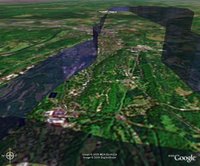
C22 is just a little field about a half mile from nowhere. Nestled away just on the other side of Weiss Reservoir, its the home of about a half dozen airplanes and is (I believe) a rest stop for the local arm of the airborne State Patrol. An old building with a head and not mush else. Sprint service was not available.

We stretched our legs and switched positions (headsets, flight bags, etc.) and I got my foggles and approach plates ready. My copilot checked the oil, seemed to be OK. So we jumped in and started her up. Everything looked good so I made the call to back taxi on 27. This was something new for me as I haven't had many opportunities to take off from small fields like this in a long time. It was only after I had gotten to mid field that I thought about the run up. Hmm. Well, I took position and just did a 'quick' run up before takeoff. No other traffic around so this was probably OK, but in the future I'll do it before taking the active. Also, doing anything 'quick' requires extra vigilance. It opens up all sorts of opportunities to miss things.

Takeoff and climb out on course normal. Local brush fires only made the haze worse, but we were flying east now so the visibility wasn't quite so bad. I leveled at 3500 direct to the RMG VOR. That acts as a feeder fix for the GPS RWY 4 Cherokee County. Airwork and procedures were good. I really felt "on" with enroute procedures and airwork. Maybe a minor 'flub' or two enroute on the radios, but overall I flew up to my standards.

The approach went well, although my copliot thought I was a bit high on final. It was hard for me to tell as I had foggles on and by now it was night time. He told me that the '5 clicks' worked and as I neared the final waypoint I executed the missed. I was very comfortable with course control.

Next task was to prepare for the ILS at RYY. I climbed up to 3000, roughly heading East and dialed up Comm 1 to talk to ATC. We were assigned a squawk and told to fly south while he tried to find us. AMICETAM complete, radar contact and vectors to the final approach course. However he allowed us to pass through the localizer before the final vector to intercept. This is when having a GPS is so helpful for situational awareness. We both caught it, but it was great to have it confirmed by the 430. Just as I was approaching the FAF he called to have us turn north to allow closing jet traffic to pass. Actually this was good news since I wanted to fly this one on speed rather then sprint down the glideslope. Vectors back around and we were once again ready to go.

This was one of those few times when I was 'wired' to the gauges. The needles were dead centered on the donut, speed was good and rate of descent was just about 500 fpm. Corrections were minor and seldom did I get outside the ring...until about 500 feet above DH. Bing(1), the course needle jump about 3 points to the right! This was NOT me! Copilot said he was watching the airplane move left of centerline, but the needle was dead on centered until the jump. I made the correction, completed the checklists and made an 'OK' night landing.

Back at the school we asked a CFII about it, and he verified that I had VLOC selected, no red flags, etc. We'll play with it now to see if it can be reproduced. The good news here is that I'm very comfortable it wasn't my airmanship.
C172p
Time = 1.3

This was a big confidence builder. Airmanship is getting back to where it should be, procedures are becoming natural. I Still have a way to go, and am learning more about 'practical' flying every flight, but I'm finally comfortable.

*Good news: I learned that there is a good chance that a Tiger will be back in the fleet soon! While I have learned to enjoy the 'high wing wonder' I'm anxious to get back into a Grumman.

Saturday, March 11, 2006

Pell City, Alabama

The objectives of this flight: 1) enroute IFR procedures, 2) non-precision approach, and 3) that $100 Hamburger.

It looked like the planets had aligned and weather gods had finally agreed to allow us to venture west to Pell City (KPLR) in St Clair County, Alabama! While we had originally scheduled the airplane for 9:00 am local, we decided to wait for the remains of the windy cold front to completely pass and rescheduled for 3:00 pm. I arrived about an hour early so we could brief and do a final weather check. I had filed IFR from home (still very cool, although the AOPA Real-Time Flight Planner was down due to a Jeppesen server problem). The weather was very clear and not an issue. I decided to exercise some cockpit management and asked the Safety Pilot if he would handle all communications during the flight. (Since he is working toward his IFR rating it would give him some experience talking to the controllers, and with some reservations, he agreed.)

I filed Dalas/V325/GAD/STAMP/KPLR which uses STAMP as the feeder fix for the GPS RWY 20 into Pell City. I warned the copilot to expect HEFIN with V321 up to GAD and that was what was given. Clearance Delivery warned us of an annoying whine on our radio, and without missing a beat my copilot said he would tell "the pilot to keep it down". Earned him a chuckle from them and a snarl from me. Runup and take off went fine, although it took a little longer then normal for Tower to hand us off to ATC. Level at 6000 we were getting bounced around a bit, so I had the copilot ask for 8000, which is pretty high for this old bird, but she was able to maintain a 500 fpm rate. It was smooth at 8k and just about above the scattered layer. It was fun to slice a few of the wisps up there. We were cleared "our own navigation" direct GAD. We passed about 10 miles south of Cedartown (4A4) and heard the "getting ready to unload" message from the Sky Divers there. (Maybe Nate?)

During the climb my copilot suggested that I lean the mixture. I have always left that as an item on the cruise checklist, but he does it during the climb. What is the best practice here?

My enroute airwork was OK, but not as crisp as I would like. At one point I got 200 ft low, unexceptable, but overall the trip out was fine. I had some time to play with the autopilot, and it did well in both Navigation and Heading modes, although I kept my eye on it closely and it didn't behave as well as I would like passing waypoints. (Seemed to initiate the turns late.)

We asked for and were granted the full GPS RWY 20 approach. I put the foggles on and went through my checklists. Pretty standard fare, left 90 degree at the IAF, right 90 degree turn outside the FAF with about a 3 degree glideslope. I got down OK, but the course work was terrible. I never really captured the final approach course and struggled with large serpentine curves. (Mine is the yellow track.) Ouch. Clearly I need more practice.

There were two other planes in the pattern (uncontrolled field) including a homebuilt (Challenger?). When I took the foggles off I could see he was on final infront of us, and felt the spacing was pretty good. I misjudged how slow he was going and executed a go-around when he failed to clear the runway in time. One lap around the pattern for a nice landing at a strange field.

So this was a good trip out to St Clair County airport. We reached 8351 ft (Updrafts through the tops of the clouds) went 131 miles and reached a max ground speed of 141 mph.

C172p
Time = 1.8

Sammie's Touch 'n Go is listed in the $100 Hamburger Guide as the best 2006 Fly-in restaurant in Alabama, and you won't get an argument from us. We called the flight school to insure no one had the airplane after us, and to let them know we would be back late. You can taxi right up on the lawn in front for place to park. It is a large 'log cabin' style building decorated with extensive aviation memorabilia. While they opened a bit late, the service was good and the hamburgers were great. Wash it down with a little "sweetea" and you're good to go. Very reasonable price (especially since my copilot paid), it earned every one of the 5 hamburger rating. I'm already looking forward to a return trip with Kathy.

The trip home was his, night time. He called and got a Wx brief and decided to go VFR to potentially take advantage of an approach at Talladega or Anniston. The front had stalled in southeast Georgia, and there were some clouds in the area, and even forecast for possible thunderstorms there, but our route should be fine. The plan was to fly east , stay south of the restricted area (R2102-A), then head Northeast to Cartersville (VPC) and pick up vectors for the ILS 27 at home.
Startup and taxi were normal ( except going on the grass instead of asphalt until away from Sammie's) and runup was fine. We called a few times to make sure no one was on final, then taxied into position for take off. 5 clicks on the radio and the lights came on. I'm sorry, I think that is really cool and just plain beautiful!

He climbed on course up to 3500ft to the TDG VOR, staying north of the airports and checking in on the CTAF for traffic. Visibility was good and the cloud bases still seemed to be up close to 8000ft. Passing KANB we noticed a 'dark spot' off to our left, and decided to stay clear (cloud?). Turns out it was a mountain. The VFR Sectional gives the quad height of 2500, but the IFR chart showed an MEA of 4000. He decided to climb up to 5500 just to be comfortable. Lesson here is that when you feel uncomfortable, do something about it. Going to 55 was a good decision. The rest of the enroute portion of the flight was uneventful, except for the shear beauty of flying at night. I said it looked like the earth was coverd in black velvet with amber jewels sprinkled all over. "King of the world" comes to mind.

We got our squawk but had trouble staying in radar contact. So we accpted an easterly heading with hopes that ATC would pick us up in time to turn us in for the ILS. Not much traffic on a Friday night, so keeping clear of everyone was pretty easy. Sure enough, we got radar contact back prior to AKONE (FAF) and were cleared (VFR) for the approach. Unfortunately, he didn't do much better then I did (serpentine approach) but made a nice landing. 150 miles, got up to 148 mph and a max altitude of 5927 ft.

Time = 1.3

This was a GREAT training flight. Enjoyable company, fine food, and a touch of adventure. Does it get any better the that? (Doubtful)

Thursday, March 02, 2006

Gadsen, Alabama

The objective of this flight: IFR enroute procedures.

The weather was 'iffy'. A cold front was slowly moving down from the Northwest pushing some clouds and rain in front of it. We had planned to fly to KPLR for a $100 Hamburger, but low ceilings and gusty winds made the Go-No Go decision hard. My practice pilot decided to wait for a better day, and by 3:00 I had just about decided to do the same. I called local ATIS one more time and found that at least around here, conditions had improved. So, why not go out and get some actual IFR time shooting the ILS?

By the time I got to the airport, winds were still gusty, but ceilings had gone from overcast to broken. So, I filed IFR to Gadsen Muni, just a waypoint on the way to Pell City, but in the right direction. I don't have much solo IFR time, so this could be interesting. It would give me a chance to practice, as well as play with the GPS a bit (what does that OBS button really do?)

Ground work was all normal, however my clearance came back a bit different then filed. ATC wanted me to go down to HEFIN, then up V321 rather then the shorter DALAS/V325 I filed. Longer route, but I was trying to get some enroute IFR time, so no complaints. *Note: "FAA has suspended all 'position and hold' clearances until further notice." First time I heard that one. Takeoff was normal, climbed to 4000 ft, expecting 6000 in ten minutes. Radar contact, I'm cleared direct GAD. (So much for planning.) I get to punch through a few little white puffy ones before getting on top, and the weather starts getting...nice. Where's my IMC? I guess the front ran out of moisture because the clouds got thin and then vanished. Head winds at about 40 kts with a bubble here and there, but nothing extraordinary. Maybe I can log a tenth.

So I enjoy the trip. Polish airwork, play with the 430, shoot a low approach (GPS RWY 24) and head for home. Vectors for the ILS are a bit interesting as I have two twins in the row behind me so am asked to keep my speed up. a 172 can only go so fast. It turned into a nice approach (although VFR) and a sweet landing.

221 miles, with homeward winds I reached 163 mph and was above the clouds at 6053 feet. This was a good flight. Every so often its nice to spend some time alone up there.

C172p
Time = 2.3