 The objectives for the flight were: 1) Communications with ATC, 2) Fly an approach with an Arc, 3) some partial panel work, 4) cross country considerations (IFR enroute).
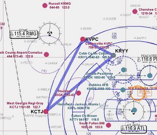
The plan was to fly down to West Georgia Regional (CTJ) and treat it as a x-country flight. Then up toward the Rome VOR where the CFI would specify an arc to fly to the initial approach fix (IAF) for the Localizer approach into Cartersville (VPC) and end with vectors to the GPS RWY 9 at home (RYY).
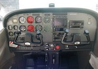
There was a new twist tonight. My instructor introduced me to another student and asked if it would be OK for him to come along as an observer. It is common for qualified Private Pilots working on their instrument rating to have a 'Safety Pilot' come along for practice flights. (The two students can split the costs, and don't need to pay for an instructor.) Three 'full sized' men meant that we needed a bigger horse, so I got to fly a different, newer Cessna, C172S - (N2165L). It has a 180 HP engine, fuel injection, and a nice Nav package (but not the Gamin GPS I'm accustomed to using).
The briefing went well and focused on GPS x-country operations. (objective 4) What are the minimum altitudes you should use when going direct from point A to point B? (Not on an airway, is the MEA relevant? What about obstruction clearance? What happens if you have a GPS failure/electrical failure/comm failure while tracking to an unpublished way point?)
Flight down to CTJ was fine, beautiful evening, smooth air, but I had 'foggles' on so didn't see the sunset. (Although I was told it was spectacular.) Shot the full (with procedural turn) ILS RWY 35 without a problem. Airwork is getting solid now, no issues with glide slope control.
Executed the missed there, climbed up to 3500 and headed toward RMG. The CFI asked me to do a 7 mile arc from south to east to intercept the 080 degree radial and fly outbound on it to VPC (kindasorta objective 2). Flying an arc is an interesting exercise (example). You actually break it down into small straight segments, correcting in or out as necessary to maintain the correct distance from the navaid. The trick is to figure out the entry (which way to turn) and then when to make the corrections. I knocked some more rust off my neurons and dove in. These days, its nice to have a GPS that provides a picture (but to be honest, I forgot to use it until I was about half way through the arc.)
Once I intercepted the radial, he placed some instrument covers over the Attitude Gyro and the Directional Gyro. This simulates a vacuum pump failure and is called flying "partial panel"(objective 3). The trick here is making turns. The compass is unreliable while turning, so you are forced to make 'standard rate' turns. (2 minutes to turn 360 degrees.) So, you first calculate how far to turn (080-005= about 90) then figure the number of seconds (about 30) then punch the clock and start the turn. Roll out after 30 seconds, check the compass and correct as necessary.
 Altitude changes are done by setting the known RPM, flying the right airspeed, and closely checking the VSI and altimeter as always. Needless to say, the pilot is very busy...and yes, if this actually happened in IFR conditions you declare an emergency and get all the help (radar vectors) you can get. Now a big advantage today is (again) GPS. It has actual track over the ground information, and some even have a built in Directional Gyro. No it is not 'cheating' to use this.
With full instruments back, the GPS RWY 9 back home was uneventful.
Another good work out, no question that I was tired by the end of the flight. I'm satisfied with the progress I'm making and feel that I'm getting close to where I should be. My headwork is getting better. A few more flights should do it.
Unfortunately my poor little 96c was stuck in my flight bag under a pile of stuff and probably couldn't find any satellites. No track this time.
C172S
Time = 1.7
*Congratulations Mandy! Last night was her Off Broadway Debut to an Actors Equity audience for "Tick Tick Boom". While still waiting for official reviews, I'm confident this was just an outstanding performance.
1 comment:
Dave,
Great blogging! I've added you to the blogroll. On question: how do you plot your post-flight maps?
Post a Comment