Thursday, October 27, 2005

IFR 5 - Arc

The objectives for the flight were: 1) Communications with ATC, 2) Fly an approach with an Arc, 3) some partial panel work, 4) cross country considerations (IFR enroute).

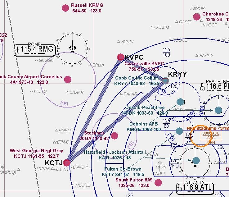
The plan was to fly down to West Georgia Regional (CTJ) and treat it as a x-country flight. Then up toward the Rome VOR where the CFI would specify an arc to fly to the initial approach fix (IAF) for the Localizer approach into Cartersville (VPC) and end with vectors to the GPS RWY 9 at home (RYY).

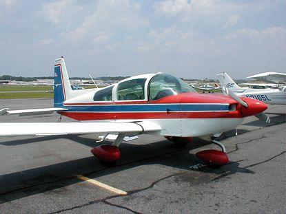
There was a new twist tonight. My instructor introduced me to another student and asked if it would be OK for him to come along as an observer. It is common for qualified Private Pilots working on their instrument rating to have a 'Safety Pilot' come along for practice flights. (The two students can split the costs, and don't need to pay for an instructor.) Three 'full sized' men meant that we needed a bigger horse, so I got to fly a different, newer Cessna, C172S - (N2165L). It has a 180 HP engine, fuel injection, and a nice Nav package (but not the Gamin GPS I'm accustomed to using).

The briefing went well and focused on GPS x-country operations. (objective 4) What are the minimum altitudes you should use when going direct from point A to point B? (Not on an airway, is the MEA relevant? What about obstruction clearance? What happens if you have a GPS failure/electrical failure/comm failure while tracking to an unpublished way point?)

Flight down to CTJ was fine, beautiful evening, smooth air, but I had 'foggles' on so didn't see the sunset. (Although I was told it was spectacular.) Shot the full (with procedural turn) ILS RWY 35 without a problem. Airwork is getting solid now, no issues with glide slope control.

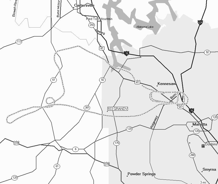
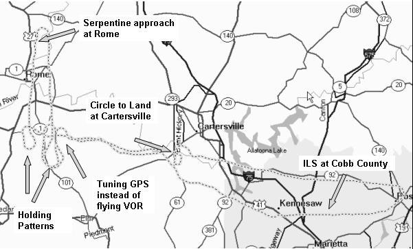
Executed the missed there, climbed up to 3500 and headed toward RMG. The CFI asked me to do a 7 mile arc from south to east to intercept the 080 degree radial and fly outbound on it to VPC (kindasorta objective 2). Flying an arc is an interesting exercise (example). You actually break it down into small straight segments, correcting in or out as necessary to maintain the correct distance from the navaid. The trick is to figure out the entry (which way to turn) and then when to make the corrections. I knocked some more rust off my neurons and dove in. These days, its nice to have a GPS that provides a picture (but to be honest, I forgot to use it until I was about half way through the arc.)

Once I intercepted the radial, he placed some instrument covers over the Attitude Gyro and the Directional Gyro. This simulates a vacuum pump failure and is called flying "partial panel"(objective 3). The trick here is making turns. The compass is unreliable while turning, so you are forced to make 'standard rate' turns. (2 minutes to turn 360 degrees.) So, you first calculate how far to turn (080-005= about 90) then figure the number of seconds (about 30) then punch the clock and start the turn. Roll out after 30 seconds, check the compass and correct as necessary. Altitude changes are done by setting the known RPM, flying the right airspeed, and closely checking the VSI and altimeter as always. Needless to say, the pilot is very busy...and yes, if this actually happened in IFR conditions you declare an emergency and get all the help (radar vectors) you can get. Now a big advantage today is (again) GPS. It has actual track over the ground information, and some even have a built in Directional Gyro. No it is not 'cheating' to use this.

With full instruments back, the GPS RWY 9 back home was uneventful.

Another good work out, no question that I was tired by the end of the flight. I'm satisfied with the progress I'm making and feel that I'm getting close to where I should be. My headwork is getting better. A few more flights should do it.

Unfortunately my poor little 96c was stuck in my flight bag under a pile of stuff and probably couldn't find any satellites. No track this time.

C172S
Time = 1.7

*Congratulations Mandy! Last night was her Off Broadway Debut to an Actors Equity audience for "Tick Tick Boom". While still waiting for official reviews, I'm confident this was just an outstanding performance.

Friday, October 21, 2005

IFR 4 - Say Again?

I had four objectives for this flight: 1) I wanted to practice communications with ATC, 2) I needed to refine my air work especially on Glide slope, 3) I wanted to fly an arc approach, and 4) I wanted to file a flight plan.

I planned to fly the ILS RWY 8 at Fulton County (Charlie Brown), the GPS RWY 7 at Gwinnett County (Briscoe Field) and the ILS 27 back into Cobb County (McCollum Field). The relative close proximity meant I would have to work hard to stay ahead of the airplane.

The preflight briefing went well, and since my plan would keep us close to Atlanta, my instructor asked that I file a flight plan (Objective 4). Not a problem. Really just a matter of filing in boxes on a form and calling Flight Service to activate it. (This can be done from the PC these days.)

The preflight was normal. Once started I adjusted the radios so that I was ready for Charlie Brown. I also had to add a step to get a clearance, the reason for the flight plan. It is important to have a pencil ready becasue all instructions must be read back correctly.

Normal Taxi and runup. (Low voltage light had me reset the electrical power, which meant I had to reload the GPS...but no real problem with that.)

After takeoff McCollum tower had me swicth to Atlanta Approach control. One button push on the GPS. They were very busy. It seemd like five minutes before I could break in and identify myself. "Roger Cessna 361 come left heading 120 climb and maintain 4000. State intentions." (Objective 1) No problem, I flew as directed, read back the clearance and asked for the ILS RWY 8 into Fulton County. "Unable 361, State intentions." Brain Freeze.

The instructor helped me out and asked for vectors to VOR A instead. So, some shuffleing to get the right approach and go through my 'gouge'. This is a pneumonic or acronym pilots use to remember stuff:

MICEATM: Marker beacon and align directional gyro to Magnetic compas, identify (the navaide), Course (final approach course), Entry (radar vectors, or as published), altitude(key altitudes for the approach),Time(if needed for the missed approach), Missed approach (procedures). Adding an "A" in front for ATIS (weather and runway information), makes it "A mice ATM".

Airwork was good, really for the entire flight. I need more polish, but flying the airplane is not my problem. Keeping my head in the game is. I must always ask myself what is next, what else can be done, how do I prepare for the next event. I'm not quite back to that way of thinking.

ILS into Briscoe went fine (objective 2), but along the way the airplane instrument lights failed. Time for flashlights. Always have one ready when flying at night.

Missed approach there, radar vectors to ILS back home. No real problems with that one either. Night landing was uneventful.

A GREAT training flight. I learned much, but still have much work to do. I'll find another approach with an arc for next time. (and yes...it really is fun!)

*My thanks to John R (http://johnsflightlog.blogspot.com) for his idea about using Google Earth. Pretty cool! There are three tracks depicted, which represent my flights for October.

Cessna 172p
Time = 1.9

Tuesday, October 18, 2005

Nates 2nd

The Flight School had a window from 11:00 to 1:00 for N53361, and the weather is 'severe clear'. Upon arriving I'm told that the vacuum pump is 'squirley', but for my purpose, this is not a problem. (I'll be practicing partial panel later, but with the outstanding weather, the Directional Gyro and Attitude Indicator aren't mission critical.) Normal preflight, taxi and runup. Nate does all of the checklists for me. Position and hold. I explained what to expect and let him take off. Pretty good job, nice rudder control.

We depart to the west in the general direction of VPC. Talk about airspeed, outside reference and trim. Complete the checklists, etc. We can see to almost forever. Level off at 3,500 feet, and do some basic airwork maneuvers. Turns, climbs, and descents. He does a nice job, very easy on the controls. I think Skydiving has given him "air sense", but I'm not sure if there is a real correlation.

My turn. Back to RYY for some T&Gs. ATIS has changed to Xray, but it is as nice as can be. Light winds right down the runway. Listening for tower calls, looking for traffic and explaining what I'm doing gets a bit hectic, but all works out fine. I abort the first landing (not bad, just not what I wanted) and make two more and a full stop. Nice workout, and I was really glad to have the company. We coverd 89.2 miles, climbed to 4822 feet and had a max speed of 141 mph.

Cessna 172P
Time = 1.2

Wednesday, October 12, 2005

IFR 3 - Aviate, Navigate...

...Communicate. I decided to reduce the number of variables and let the instructor do the talking. I just wanted to concentrate on flying...good basic airwork and solid navigation. We planned the GPS RWY 4 at Cherokee County (47A), my first ever GPS approach, followed by the Localizer RWY 19 at Cartersville (VPC) and finished with the VOR/DME RWY 9 at home (RYY).

The GPS is pretty straight forward, once you get the 'knobology'. Its almost like dialing your cell phone while driving a stick shift in stop and go traffic. Its easier if you have speed dial set up, so I need to learn all of the short cuts to get the Garmin 430 set up quickly. The simulator really helps, and the instructor was able to polish that knowledge a bit more with some good advice. (Direct/enter/enter). My airwork was good. I was able to stay ahead the whole flight without any problems, much better the IFR2.

LOC Rwy 19 was also good. I need to polish my procedures here. Get all of the necessary checklists done (MICEATM), and insure all of the timings are started correctly. I was ahead of the plane, and had not listened to ATIS or CTAF. I need to organize myself better, but overall the approach went well. No longer chasing the needle, instead I put a correction in and wait for effect (about 3 scans) before correcting again. Also, I talk to myself the whole way down stating target heading and next target altitude. That really works. Level off OK, but he suggested I add a bit more pitch up (about one pipper) to really stop the altimeter. Will incorporate that next time.

VOR back home was easy. The approach leaves you way out in 'left field' so it might be dicey in actual conditions, but I had no problems flying it as published. All checklist complete and squeeek on the landing! We covered 95.6 miles in what was a really good confidence builder. Now I need to learn how to talk again.

Time = 1.2

Thursday, October 06, 2005

Weathered Out


I'm learning how to fly in weather, so this should have been the perfect training flight. We decided not to go. Weathered out. I guess it comes down to my personal minimums. I recently saw a DVD with Richard Collins "The Prepared Pilot" (a part of his Air Facts series from Sporty's) and one of the topics focused on things he just would not do. Never overload the airplane, always plan to have at least an hour of fuel remaining after the trip, etc. He also talked about his personal weather minimums. So, what personal rules will I follow?
  1. IFR, solo, at night: It might happen, but I'm not going to plan on it, and will avoid it if at all possible. Accident statistics support this decision.
  2. Dick's idea to plan about an hour of gas in the tank sounds pretty good.
  3. Approach minimus will not be busted, period. (No 'taking a peak'.)
  4. No re do. If the first approach was flown right, no sense going back again because the weather hasn't changed. Go someplace else (with better weather or lower approach mins).
  5. No 'circle to land' at a strange field at night.
  6. Don't continue a flight with things that are inoperative for the sake of making a meeting, job, or family.
  7. Icing is bad. Always check for icing conditions before the flight. Be prepared to change plans if icing is encountered.
I'll have to think about some others.

The pictures at the top represent a "no go" situation. The weather at the field (KRYY) is lower then the published minimums (green arrow) for the most likely approach. Too bad, I was really looking forward to flying tonight, but not into the remains of tropical storm Tammy.

Thursday, September 29, 2005

IFR 2 - Chasing it


We spent some time briefing this one and decided that the best use of time would be the ILS/DME 1 into Rome (RMG - I-HBQ), followed by a simple VOR/DME A (RMG) into Cartersville and finally an ILS 27 (I-RYY) back home. Pretty straight forward with no apparent tricks, as long as I stayed ahead of the aircraft. I didn't.

The departure was uneventful and the climb to 4500 went fine. I had the 284 from RMG dialed into #2 Nav, Localizer with 007 in Nav #1 with GPS backing up the approach. I chased the needle a little bit inbound, but the rest of my air work was solid. The holding entry to approach was straight forward(right turns - parallel) and I looked good at the initial approach fix (IAF). It went down hill (in more ways then one) from here. I intercepted the glide slope normally, but started chasing the needle for heading. I should have picked a course to fly and let the needle correct, instead I kept chasing it all the way down. Pretty ugly

Missed was fine, back to holding at RMG (left turns - teardrop) , but I was late doing checklist and getting Navaids set up for the VOR into Cartersville. Just plain ugly. Busted mins, chased the needle, overall just worked way too hard. Circle to land went well, and the landing was great.

Picked up radar vectors for the ILS 27 back home. Had to just fly straight for awhile...gave me a chance to think ahead. Everything was set by the time I intercepted the final approach course. I flew course this time, calling out the corrections to myself all the way down. This worked well. Took the glasses off at mins for a beautiful setup for landing. I blew the landing.

Hard, hard workout, but a great training flight. The course covered 165 miles. My cockpit organization is lousy, my procedures are rough, but I'm optimistic. I can do this...and it is REALLY fun!

Time 1.9

Monday, September 26, 2005

Homework


I can remember sitting in a one bedroom apartment, studying a small plastic RMI. Three of us would give different holding instructions while the others tried to figure out the correct entry procedure. Things have changed. Now GPS allows you to see the pattern, provides a direct track to the entry point, and even provides the recommended entry. If only I had been able to have this then. Technology is great. The simulator can be downloaded for free from the Garmin website. Couple this with MS Flight Simulator you can fly the entire lesson while sitting at home with the computer. While the PC doesn’t provide the ‘feel’, it does give you the situational awareness needed to anticipate what the approach should look like.

Thursday, September 22, 2005

First Instrument Flight


After taking off he handed me some "foggles" to put over my glasses so that I could only see the instruments. I continued to climb, turning north to get up to the practice area. I wanted to get the 'numbers' straight. How many engine rpm are necessary to climb at 90kts, what is the pitch up attitude, how many feet per second will that yield? Same for descent, slow flight, etc.

Next I did a Localizer Approach into Cartersville (the straight portion heading south next to route 293), missed approach and did a VOR approach back to Cobb County. I took the glasses off at pattern altitude for the approach, and did a 'circle to land' (left base) to a "squeaker" full stop landing.

It took a little under an hour, but I was so busy it felt like 5 minutes. More approaches (including an ILS) next week.

Total Time = 0.8

Saturday, September 17, 2005

Cessna


I got checked out in a Cessna 172P last night. I thought you might be
interested in the track. As you can see, we did a number of T&Gs, some
slow flight and steep turns up at the lake, then back (right base) for
some no flap landings. The last was particularly interesting as he
chopped power 700 ft immediately after Take Off and I did a 'tear drop'
back to the opposing runway. A lot of fun.

Time = 1.2

Friday, August 19, 2005

D.R.

It was time for an exercise. I wanted to navigate the "old way", by planning a flight, drawing lines on a map, and using dead reckoning and visual landmarks on the ground to get from "Point A to Point B". No GPS for this one. I took off solo from KRYY in a Warrior on a Friday morning to avoid the afternoon CBs. First point was Calhoun (CZL), pretty easy as it is just up I75. Next, over to Dalton (DNN), was a little more difficult. Roads are not as prominent as you might think, and there are a lot of tress out there. Even a little haze makes searching the ground difficult, but after a few long minutes the airport was in sight. Finally, the leg home was along a road, keeping the ridge line on my left an looking for the lake. No problem. Entered with a right downwind to a full stop. In can be done...but it sure is nice to have a moving map

Time = 1.3

Friday, August 05, 2005

T&Gs

The weather stinks. The plan was to go out and tour the local area, but visibility is less then 5 miles in haze, so we won't see too much. Kathy decides she wants to come along, and while she has an anti-airsickness device, I'm skeptical. I love to do Touch and Go's. To me they encompass everything in flying; climb, transitions, and landings. But these are not good for someone prone to air sickness. She did great! Four T&Gs in the Warrior plus the full stop. A nice way to spend a summer evening.

Time = 0.5

Saturday, July 09, 2005

Kathy's 2nd


Saturday morning, sunny and dry, with yard work and lots of house work to do. Kathy finally asks;"Can you get the airplane today?" A quick call to the school and I find out that the Warrior is available. Drive over to KRYY and it is really busy. Some Warbirds are in selling rides for a charity. I get the dispatch kit and have her wait in the A/C'd lobby while I do the preflight. I take extra time to brief her on what we will do, what to expect, what things to look for. I also have her read the checklists for me, keeping her involved in the progress of the flight. It is hot!

Taxi checks, run up and take off go fine. Depart to the NW for some simple cruising, and let her fly for a bit. It is going well. Nice easy turns, good horizon, slow climbs and descents. I don't do anything to disturb that inner ear.

Fly over toward Cedartown, where Nate skydives, and listen to CTAF for traffic. No problems, but decide not to risk a T&G, just wander back toward home. All is going real well, she is comfortable, even smiling. Upon contacting the tower I'm told that my traffic is a P51. Can it get better then that? Oh, according to my faded old logbook, her first flight with me was over 31 years ago.

Time = 1.2

Friday, June 17, 2005

Humility


It seemed simple enough. I had been flying a low wing airplane for awhile now, and still liked the round out, transition, and flare that is unique with the wing in ground effect. The weather wasn’t real good, with lots of ‘bumpers’ in the area, so we decided to stay in the pattern and bounce. First one was OK, but the picture wasn’t quite right. Next was left of centerline and fast. It went down hill from there. It just seemed that the airplane was fighting me. I would have a “happy airplane” on base, but turning final things would fall apart. Finally, after numerous attempts, my instructor had pity on the airplane and called it off. Time to try it another day.

Time = 1.2

What happened? A long night flying in my easy chair in front of a silent TV gave me time to replay the flight. First, the pitch was all wrong, because the Tiger is faster and flatter then a Warrior. Second, I was off speed by always coming in too fast. Third, I spotted the deck. I was landing left of CL and in concentrating on that I failed to scan the entire runway prior to the flare.

The first thing I needed to do was go out to the practice area and see a stall. That would help to visualize the correct pitch attitude. Next, I needed to get the basics right. If the approach speed is 74 kts, then don’t fly it at 80 kts. Finally, don’t fixate or ‘spot the deck’. Keep eyes moving all the down the runway.

I got checked out on the next flight without problems…which included a couple of ‘squeakers’.

Time = 1.3

Thursday, June 09, 2005

Nate's 1st


The weather has been lousey. Lots of t-storms, normal for summertime in Georgia. We've been weather'd out twice so far, and I'm not sure about today. I've been unable to get into an airplane for more then a week. Nervous, excited, and iffy weather, is not a good recipe for success. Fortunately I get a Pirep from a returning pilot saying that its pretty good to the south and west, just where I want to go. We can at least take a look. We take off about an hour late (fuel and oil) on 09 with a right hand pattern. I tell the tower that we'll stay in the pattern for T&Gs. The first is high and fast (missed) but the next one good. We depart for Cedartown (KCZL) and the weather turns beautiful! We watch a C5 out of Dobbins circle way out in front of us and we bounce just a bit when we pass through his wake. I make a sloppy entry but a nice T&G. Nate is having fun and I feel great. Straight in back at KRYY to a beautiful landing. Kathy is there to welcome us and take some pictures.

Time = 1.2

Friday, May 27, 2005

Solo


This was it. Nervous but confident. The instructor wanted to see some Lazy 8’s and chandelles out in the practice area. I looked up the definitions on AOPA.com, but was unable to visualize exactly what the pilot should see. Slow flight, stalls, and all the procedures to taxi, T.O, depart and enter a controlled field are all easy now. Not perfect, but I am comfortable and confident. It goes well.

Time = 1.2

The next day is my first solo in nearly 25 years. The weather is fine, no problems with the airplane, and I can’t think of a better way to spend a Friday afternoon. I just want to stay in the pattern for T&Gs. My air work is a little sloppy, but head work is fine. It’s peaceful. This is good stuff, its fun.

Time = 0.6

Sunday, April 10, 2005

What's New

The first entry in my logbook dates back to the late '60s. I flew a Cherokee 140 and built time in an Aeronca Champion. I think both of those planes are probably still flying. The airplanes I'm flying now date back to the early '80s. Not much new there. ATC really hasn't changed much, TCA's are now Class B and Victor airways are still drawn on the charts.

What has changed is what is in the flight bag. When I walked up to the Champ, I didn't even have a flight bag...didn't need one. The biggest improvement is in headsets. I can actually hear the instructor and the tower, and if needed the navaid dit-dah in the background. It is comfortable to carry on a conversation.

Of course its also nice to have the technomagical stuff like a hand held GPS and Transceiver (just in case...), but by far the biggest improvement in the cockpit are headsets.