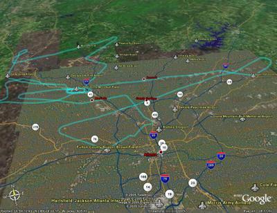
 I had four objectives for this flight: 1) I wanted to practice communications with ATC, 2) I needed to refine my air work especially on Glide slope, 3) I wanted to fly an arc approach, and 4) I wanted to file a flight plan.
I planned to fly the ILS RWY 8 at Fulton County (Charlie Brown), the GPS RWY 7 at Gwinnett County (Briscoe Field) and the ILS 27 back into Cobb County (McCollum Field). The relative close proximity meant I would have to work hard to stay ahead of the airplane.
The preflight briefing went well, and since my plan would keep us close to Atlanta, my instructor asked that I file a flight plan (Objective 4). Not a problem. Really just a matter of filing in boxes on a form and calling Flight Service to activate it. (This can be done from the PC these days.)
The preflight was normal. Once started I adjusted the radios so that I was ready for Charlie Brown. I also had to add a step to get a clearance, the reason for the flight plan. It is important to have a pencil ready becasue all instructions must be read back correctly.
Normal Taxi and runup. (Low voltage light had me reset the electrical power, which meant I had to reload the GPS...but no real problem with that.)
After takeoff McCollum tower had me swicth to Atlanta Approach control. One button push on the GPS. They were very busy. It seemd like five minutes before I could break in and identify myself. "Roger Cessna 361 come left heading 120 climb and maintain 4000. State intentions." (Objective 1) No problem, I flew as directed, read back the clearance and asked for the ILS RWY 8 into Fulton County. "Unable 361, State intentions." Brain Freeze.
The instructor helped me out and asked for vectors to VOR A instead. So, some shuffleing to get the right approach and go through my 'gouge'. This is a pneumonic or acronym pilots use to remember stuff:
MICEATM: Marker beacon and align directional gyro to Magnetic compas, identify (the navaide), Course (final approach course), Entry (radar vectors, or as published), altitude(key altitudes for the approach),Time(if needed for the missed approach), Missed approach (procedures). Adding an "A" in front for ATIS (weather and runway information), makes it "A mice ATM".
Airwork was good, really for the entire flight. I need more polish, but flying the airplane is not my problem. Keeping my head in the game is. I must always ask myself what is next, what else can be done, how do I prepare for the next event. I'm not quite back to that way of thinking.
ILS into Briscoe went fine (objective 2), but along the way the airplane instrument lights failed. Time for flashlights. Always have one ready when flying at night.
Missed approach there, radar vectors to ILS back home. No real problems with that one either. Night landing was uneventful.
A GREAT training flight. I learned much, but still have much work to do. I'll find another approach with an arc for next time. (and yes...it really is fun!)
*My thanks to John R (http://johnsflightlog.blogspot.com) for his idea about using Google Earth. Pretty cool! There are three tracks depicted, which represent my flights for October.
Cessna 172p
Time = 1.9
3 comments:
Cool ground track. I can't tell, were you able to get the altitudes to come over into Google Earth?
Thanks guys...got it working now. Missed the check box the first time.
"Keeping my head in the game is. I must always ask myself what is next, what else can be done, how do I prepare for the next event."
I know what you mean by this exactly! That is THE GAME of 4-way!! Isn't that mind game a blast, though? Especially after flying with you, I can understand vaguely how that must have felt to 'keep all the tops spinning' at once. Really fun, dad!
Post a Comment